

DA42 MPP / RIEGL BP560

Diamond DA42 MPP / RIEGL BP560
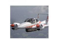
Twin engine plane Diamond DA42 MPP equipped with RIEGL Belly Pod mounted Airborne Laser Scanner System BP560-XS or XD
Listing of components:
- Diamond twin engine plane DA42 MPP
- Belly Pod
- RIEGL System 560
- INS/GPS
- FMS
- Digital Camera
Diamond Airborne Sensing GmbH and RIEGL Gmbh offer, as cooperation partners, the perfect "turn-key" solution for Airborne Laser Scanning: the Diamond DA42 MPP, a modern twin-engine fixed-wing plane with a "belly-pod" mounted, completely integrated and calibrated RIEGL airborne scanning system.
The system complies with the rules of JAR 23 and fulfills the requirements of airworthiness.
Different system configurations are available, either equipped with a single laser scanner, or with two laser scanners, one of them in a tilt-mount.
The key components are the state-of-the-art RIEGL LMS-Q560 echo digitizing laser scanner(s) and an inertial navigation system with an integrated GPS receiver (IMU/GPS) providing highly accurate position and attitude data. The system is completed by high-speed data recorders for the full waveform data (RIEGL DR560 or RIEGL DR560-RD) and an operator’s working station for data acquisition controlling.
Laser scanner(s), IMU/GPS, and the optional camera are enclosed in a rigid and durable carbon-fiber-reinforced plastic container, ensuring high dimensional stability even under high loads. Supplemented by an aerodynamically optimized cover, this pod is mounted with a 3-point mount.
An integrated software package offers all the functionality necessary to process the acquired raw data (laser scanner data, GPS raw data, IMU raw data) to attain high-precision geo-referenced data in WGS84 or UTM projection. Data is represented as point clouds, each point representing a target detected in the full waveform data, each with additional attributes from the full waveform analysis, such as echo intensity, echo width, and pre-classification.

Legend:
FMS
Flight Management System
GPS
Global Positioning System
IMU
Inertial Measurement Unit
CC
Camera Control/Storage
DR560
Data Recorder
LMS-Q560
Airborne Laser Scanner


 ?
?